Map pedestrian infrastructure in OpenSidewalks schema for areas covering 80% of the state’s population that include all the cities and the top densest census tracts.
Customer: The Taskar Center for Accessible Technology, University of Washington, Seattle

Background
Access to safe, functional sidewalks is critical for building sustainable, equitable, and inclusive communities. Yet, in many parts of Washington, data about the pedestrian environment—such as sidewalk availability, condition, and connectivity—is incomplete or unavailable. This data gap hinders city planners from setting concrete project goals or evaluating environmental and accessibility impacts. It also discourages the public from choosing active transportation options.
Under the directive of the Washington State Legislature and in partnership with Gaussian Solutions LLC, the Taskar Center for Accessible Technology at the University of Washington is creating a comprehensive, high-quality pedestrian network dataset that includes sidewalks data across the state.
The project supports equitable mobility by equipping state agencies, local governments, and community organizations with the data needed to plan Complete Streets and prioritize resources effectively. Additionally, it aligns with Vision Zero safety initiatives by enabling data-driven decisions to prevent pedestrian injuries. Updating and expanding this dataset will empower Washington to provide all residents—especially vulnerable populations—with safe, accessible, and sustainable transportation options.
The Challenge
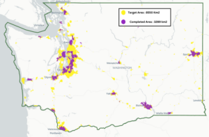
Mapping pedestrian infrastructure (sidewalks, crossings, curbs, traffic islands, etc.) for a state as large as Washington is a monumental task. Spanning approximately 185,000 square kilometers, the state’s pedestrian network is vast. Even discounting uninhabited forest areas, the target mapping area is still 8,550 square kilometers. Mapping such a large area manually would require an immense amount of time and manpower—an approach that is neither feasible nor cost-effective.

The solution
Gaussian Solutions in partnership with the Taskar Center for Accessible Technology at Paul G Allen School of Engineering in University of Washington, Seattle have developed an AI-powered pedestrian infrastructure mapping solution. This solution accelerates the mapping process by more than 100x compared to manual efforts.
Using an AI-assisted, human-in-the-loop approach, the team generates high-quality, detailed, and connected pedestrian network data. This data is invaluable to transit agencies and city planners, enabling a wide range of analyses and applications.
Progress so far
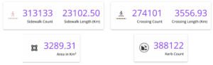
We have mapped 50+ cities across Washington State, covering 3,290 square kilometers. This includes geographically diverse locations—urban, suburban, and rural.
Key achievements to date include:
- 313,100 sidewalks spanning 23,100 kilometers
- 274,100 crossings
- 388,100 curbs
The data is delivered in the sidewalk centerline format, capturing details such as surface type, length, and incline.
What’s next
Our goal is to complete mapping for the entire state by March 2025. The next phase will focus on rural and unincorporated areas.
Stay updated on our progress by following our LinkedIn page: Gaussian Solutions LLC on LinkedIn.
If you are interested in accessing this data, reach out to us at info@gaussiansolutions.com. We’d love to hear about your projects and how our detailed sidewalk data can support them.